Maps of cities are now being generated to differentiate where people are taking photos, based on geotag data. This is a view of San Francisco (blue for locals, red for tourists):
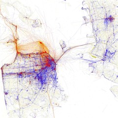
Locals and Tourists #3 (GTWA #4): San Francisco
Originally uploaded by Eric Fischer
Locals take photos in residential areas while tourists take photos in touristic areas. Should we be getting more insight out of this map?
What if we break it down by tourist home town, by gender and by age? How do tourists from Korea compare with Japan, or Germany versus France? It would seem the map becomes more informative the more sensitive/privacy data is available…and that is exactly the kind of pressure many companies feel when thinking about how to visualize their databases of customer information.