
Years ago, in my talks about future AI risks, I explained how satellites and fax machines by 1960s had become essential technology in the success of U.S. Army special force operations in Africa.
Rescue teams gathered an accurate record of building footprints in order to prepare raids and make quick work of kidnappers.
A new Google blog post about their use of AI reminded me of it.
An accurate record of building footprints is important for a range of applications, from population estimation and urban planning to humanitarian response and environmental science. After a disaster, such as a flood or an earthquake, authorities need to estimate how many households have been affected. Ideally there would be up-to-date census information for this, but in practice such records may be out of date or unavailable. Instead, data on the locations and density of buildings can be a valuable alternative source of information.
I see only a very subtle nod to the “humanitarian response” elephant in the room.
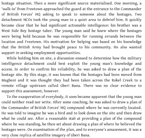
Here’s an example from “In the Shadows… Intelligence Corps”
Another time I mentioned briefly how quickly deflating cost of spatial intelligence feeds into asymmetric conflict.
One of the more interesting aspects of this new Google post is something I highlighted as far back as my 2016 talks, which is that AI engineers do not think about African geography when they develop “recognition” systems (I easily broke a Cambridge “driverless” system claiming 90% accuracy by running it on scenery from Botswana, where it immediately failed).
…taking into account confounding characteristics of different areas across the African continent. In rural areas, for example, it was necessary to identify different types of dwelling places and to disambiguate them from natural features, while in urban areas we needed to develop labelling policies for dense and contiguous structures.
It begs the question whether someone associated with military intelligence or special operations poked Google for help on a “humanitarian” mission by providing accurate footprints… in Africa. Or maybe even Google hired a spy to their dubiously funded massively expanding engineering teams.
I mean remember how Twitter engineers had been taking money from the Saudi government for access before the new CEO made it into an official strategy?