
A search on Google Maps for COVID-19 cases highlights the northern “panhandle” area of Idaho, which stands out from the rest of the nation.
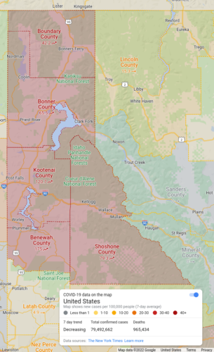
175 cases in Benewah County (population 9,285) is incredibly high. Why?
The 120 cases in Kootenai County (population 171,362) are a huge clue. Everything around Kootenai is showing spread, completely counter to the downward move everywhere else.
It looks fairly clear to me that the city of Coeur d’Alene failed in their basic duty to protect health, becoming an intentional infection center.
‘I would not vote to mandate masks’ says Coeur d’Alene mayor
Rates were at nearly half the population infected in early 2022.
Kootenai County’s positivity rate dropped to 4.3% based on 1,220 PCR tests for the week ending March 5. It reached a high of 40% just six weeks ago.
Google is pulling data from the NYT, and there’s evidence cases may be even higher than what was being reported by Idaho officials.
The Coeur d’Alene Wastewater plant conducted a test of the city’s sewage, and the results suggested as many as 490 people could be infected with COVID-19.[…] Officially, the Panhandle Health District reports that only 87 people have COVID-19 in Kootenai County.