
For decades there has been a dilemma of privacy versus safety nagging commercial malls, as compared with public spaces.
More specifically, law enforcement trying to provide safety faced a serious data ownership boundary issue when many large open spaces for assembly were privatized and controlled for profit by very small groups (e.g. corporations).
Enter detailed map and geolocation software vendors.
While many, or perhaps nearly all people, think about databases of spaces in terms of shoppers and commuters, behind the scenes are special operators training in high stakes rapid targeted insertions for hostage rescues and threat elimination.
A very long time ago we would be talking about some maps of rebel compounds traced in charcoal by hand onto a headscarf that gets imaged and transmitted by radio to rescue teams (de oppresso liber)… and “here” we are today simply talking about APIs and a finger touching a screen.
A good example of the latest achievement — very open steps for public knowledge through private space boundaries — is being showcased by German engineers at HERE working with Japanese corporations.
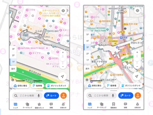
With HERE, opening Yahoo! JAPAN Maps on your smartphone will reveal a seamless navigation experience. Each shopping mall floor is clear and easy to read. For example, all stores are shaded in pink, restaurants are colored orange and additional icons for escalators, elevators, ATMs and toilets are highlighted accordingly. As you are guided through the space, you can quickly switch floors with a simple tap of your screen.
Tokyo’s shopping centers are just as fast-paced inside as the roads that surround them — powered by HERE Indoor Map, Yahoo! JAPAN Maps’ floor plans are updated monthly so any renovations or new store launches are automatically captured and made visible.
Private spaces “automatically captured and made visible” sounds like constant surveillance positioned as for good, or in other words some subtle law and order enforcement direct marketing, if I’ve ever seen it.

After all, who truly benefits from the mass privatization of open spaces especially in terms of freedoms, such as from harms?
The next logical step of this map innovation will be highly precise 3D fly-through data in VR for practice rescue training (like 1990s VRML all over again). It’s a relatively small data storage and processing market, but there’s nonetheless a lot of quiet public money fueling these seemingly large commercial efforts.