Category Archives: Sailing

USCG Arctic Shield Operation

After the end of WWII hostilities the U.S. Navy deployed “task forces” all over the world. From the South Pole to the North Pole there were military teams mapping territory, assessing risk and seeking out remnants of opposition.

At least a dozen ships with double that many aircraft were assigned to study “techniques” for operation in extreme conditions and remote locations, as well as gather information the military considered “interesting”. Whether fueled by fear, suspicion or curiosity, the missions and their findings kicked off a huge body of knowledge about survival and risk management.

One way to get a sense of the number and types of teams is to look at photographs from aviation archives. Here’s a 1947 photo from LogBookMag of a Navy Douglas R4D-5 Skytrain (AirForce C47A) launching from an air craft carrier in Operation Highjump. Note the snow skis and the use of jet-assistance (JATO bottles).

R4D-5 Skytrain Launches

JATO was effective not only for small carrier runways but apparently also came in handy after skis froze to the ground.

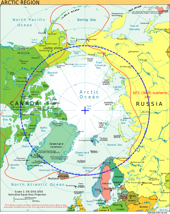
By 1951 some believed that the U.S. was at risk of attack by the U.S.S.R. from the north. The CIA Factbook map makes it pretty obvious why; the distance straight over the pole is far shorter than following a latitude.

North Pole

The threat of increased traffic warranted understanding the region, establishing forward bases and learning to operate there. The American military stepped up research on extreme temperature survival, early-warning systems and rapid-response above the Arctic Circle.

Innovations like the “flying laboratory” were developed and used in Project Skijump, although it had a landing-gear failure in 1952 and was lost to the Soviets.

Fast forward to today. The U.S. Coast Guard has announced a massive expansion of operations above the Arctic Circle and a forward base at the northernmost city in America. The Fairbanks Daily News gives their perspective on the need for assistance.

Barrow is surrounded by open tundra and the Arctic Ocean. As sea ice continues to disappear, the city will begin to experience increasing boat traffic, both from companies planning to drill for oil and travelers looking for a shortcut from the Atlantic to the Pacific.

That is why the Coast Guard sent an aviation team more than 900 miles from its home in Kodiak to Barrow: It needs to be prepared if something goes wrong.

I wonder how much of the preparation from the past is useful for future incidents. The NYT makes it sound like the USCG is starting from scratch.

“The Arctic has been identified as a priority,” said Cmdr. Frank McConnell, the operations coordinator for Arctic Shield, which includes in its initial phase two Coast Guard cutters and two smaller ships, in addition to the two helicopters that will be stationed here in Barrow. The first of 25 pilots, along with support crews, mechanics and communications personnel, began rotating through Barrow this month on three-week tours. “There’s a lot to learn,” Commander McConnell said.

That’s what they said in 1947.

A-Class Catamaran Video: 2012 German Championship

Last month I mentioned a beautiful video of the 2011 German Championship that emphasized storms and stark scenery.

Here is a video of the 2012 Championship that is much more upbeat and celebratory. The weather certainly sets the tone.

This version has some aerial views that can be grabbed to study. It is always useful to review a start line.

And here is the natural separation of the fleet, hinting at wind disturbance and shadow for each boat.

Snow on the Mountain in Kansas: Konza Prairie

It’s been a while since I mentioned the Konza and security so I thought maybe it’s time for an update. Often when Kansas comes up in conversation I hear either one or two responses from Americans:

  • The Land of Wizard of Oz! Where’s Toto?
  • It’s so flat and boring! Right? One time, I drove cross-country and Kansas seemed to take forever…

Yes and yes, but no.

First, the political and historical relevance of the Wizard of Oz and its secret story are definitely related to Kansas. I mentioned it in 2006 and noticed a lot more interest in it after the financial crisis of 2008.

US political historian Quentin Taylor, who supports [Littlefield’s 1964] interpretation, says: “There are too many instances of parallels with the political events of the time.

“The Tin Woodman represents the industrial worker, the Scarecrow is the farmer and the Cowardly Lion is William Jennings Bryan.”

[…]

The Wicked Witch of the West is associated with a variety of controversial personalities, chief among them the industrialist Mark Hanna, campaign manager to President William McKinley.

In this scenario, the yellow brick road symbolises the gold standard, the Emerald City becomes Washington DC and the Great Wizard characterises the president – and he is exposed as being less than truthful.

The little dog doesn’t really have any significance (despite some suggesting Toto represents a teetotaler) once characters are framed in 19th Century deflation and depression, with a struggle between populists and industrialists (e.g. the 99% and 1%). That is why no one knows where Toto is.

Second, I have not yet written very much here about my impression of the terrain. So here’s a good example of why flat may not really be flat. This is a photo I took a long time ago. Notice what it does to your focus. The Konza landscape was formed from glacial runoff into giant valleys. Barely hidden beneath the tallgrass are rocks and boulders.


Photo by me

At first glance it may seem to be an endless green space or a flat top. The trained eye soon realizes the open space of a tallgrass prairie belies billions of interesting data points. You might not believe it at first but snow-on-the-mountain is right there, in front of you.

Hills are formed from an inverse effect. What you see through a little window at 70 mph could be a trick on your eyes; easy to focus only on the flat top with some blur below. But take a back road that tries to conquer the elevation change or slow down and let your eyes soak up the view. When you stop you will find an incredible diversity of life at the micro level.

It’s similar to the ocean. You can stare accross the sheer expanse of it through a window and see the emptyness. Or you can ride a wave and slow down to observe life below peak elevation. If you let the data in, you might be amazed.

KEEPBison sampling data on the Konza. Photo from KEEP

U.S. Navy Supercomputers Predict Weather Threats

Calm waters mean greater chance of attack, as I mentioned recently, so weather forecasts can give a major advantage. CNet reports on the latest technology:

[The Fleet Numerical Meteorology & Oceanography Center] benefits from its immediate proximity to weather and supercomputing experts at the Naval Research Laboratory, the National Weather Service, and the Naval Postgraduate School, all of which are in Monterey. That allows Fleet Numerical’s team of just 13 officers, 13 enlisted, and 128 civilians to do a job that the National Weather Service’s own forecasting center needs at least three times the resources to do, while the U.S. Air Force’s needs twice as much, Sauer explained.

[…]

Fleet Numerical’s most powerful supercomputer is a Dell Linux cluster system known as A2 Emerald with 27.3 peak teraflops. But that runs the center’s unclassified global modeling, which brings in giant amounts of data from countries all around the world. Its classified and Top Secret computers are smaller, and are geared towards much finer resolution regional and local modeling.